


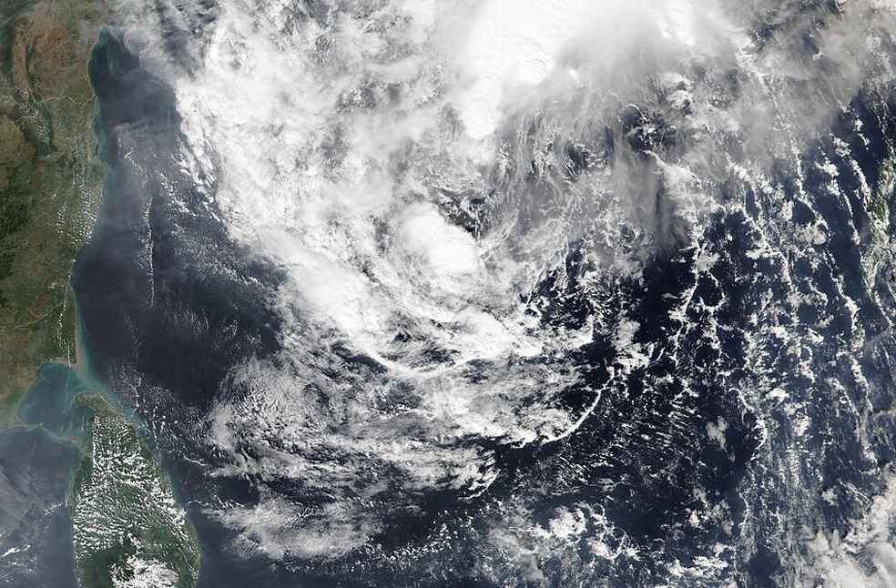
Bhubaneswar: Heavy rainfall and strong winds battered India’s eastern coastline on November 20 as Cyclone Akvan made landfall, marking the third cyclone to affect the country in less than a month, according to the India Meteorological Department (IMD).
Authorities in Odisha and Andhra Pradesh had evacuated hundreds of thousands of people from vulnerable areas earlier this week as the storm approached. Akvan weakened overnight to a cyclonic storm before crossing the coast.
The IMD reported that the system made landfall with sustained wind speeds of 70–80 kilometres per hour and gusts reaching 90 kilometres per hour.
मौसम संबंधी चेतावनी !
मुख्य बिंदु:
(i) उत्तरी आंध्र प्रदेश और दक्षिणी ओडिशा के तटों के पास, बंगाल की खाड़ी के पश्चिम-मध्य हिस्से मेंमौजूद चक्रवाती तूफान “अकवान” [उच्चारण: अकवान] ने गोपालपुर के निकट उत्तरी आंध्र प्रदेश और दक्षिणी ओडिशा के तटों को पार किया। इस प्रणाली के प्रभाव के कारण, 20 नवंबर को ओडिशा मेंकुछ जगहों पर बहुत भारी बारिश होने की संभावना है।
Highlights:
(i) The Cyclonic Storm “Akvan” [Pronunciation: Akvan] over the westcentral Bay of Bengal near north Andhra Pradesh & south Odisha coasts crossed the north Andhra Pradesh & south Odisha coasts close to Gopalpur. Under the influence of the above system, isolated very heavy rainfall likely over Odisha on 20th November.
South Peninsular India:
❖ Isolated to Scattered rainfall likely over Tamil Nadu, Puducherry & Karaikal during 20th-23rd November and on 26th November; Coastal Andhra Pradesh & Yanam, Kerala & Mahe and Rayalaseema during 20th-26th November; Lakshadweep on 24th November; Coastal Karnataka and North Interior Karnataka during 24th26th November; South Interior Karnataka on 23rd November and during 25th-26th November; Telangana on 20th November.
❖ Fairly Widespread to Widespread rainfall likely over Tamil Nadu, Puducherry & Karaikal during 24th-25th November; Lakshadweep during 25th-26th November; South Interior Karnataka on 24th November.
❖ Isolated thunderstorm, lightning & gusty winds (speed reaching 40-50 kmph gusting to 60 kmph) likely over Tamil Nadu, Puducherry & Karaikal during 23rd-26th November; Coastal Andhra Pradesh & Yanam and Rayalaseema during 22nd-24th November, with gusty winds (speed reaching 30-40 kmph gusting to 50 kmph) likely over Kerala & Mahe on 24th November; Coastal Andhra Pradesh & Yanam and Rayalaseema during 20th-21st November; Telangana on 20th November.
❖ Isolated thunderstorm & lightning likely over Coastal Karnataka and North Interior Karnataka during 24th26th November; South Interior Karnataka during 23rd-26th November.
❖ Isolated heavy rainfall likely over Tamil Nadu, Puducherry & Karaikal during 23rd-26th November; Kerala & Mahe during 24th-25th November.
❖ Strong Surface Winds likely over Coastal Andhra Pradesh & Yanam and Rayalaseema during 20th-24th November.
Central India:
❖ Isolated to Scattered rainfall likely over East Madhya Pradesh during 20th-22nd November; Vidarbha on 20th November; Chhattisgarh during 22nd-25th November.
❖ Fairly Widespread to Widespread rainfall likely over Chhattisgarh during 20th-21st November.
❖ Isolated thunderstorm, lightning & gusty winds (speed reaching 40-50 kmph gusting to 60 kmph) likely over Chhattisgarh during 20th-21st November, with gusty winds (speed reaching 30-40 kmph gusting to 50 kmph) likely over East Madhya Pradesh during 20th-21st November.
❖ Isolated heavy rainfall likely over Chhattisgarh during 20th-21st November.
East India:
❖ Isolated to Scattered rainfall likely over Andaman & Nicobar Islands during 20th-26th November; SubHimalayan West Bengal & Sikkim during 20th-23rd November; Gangetic West Bengal and Jharkhand during 22nd-23rd November; Bihar during 20th-22nd November; Odisha during 21st-23rd November.
❖ Fairly Widespread to Widespread rainfall likely over Gangetic West Bengal and Jharkhand during 20th-21st November; Odisha on 20th November.
❖ Isolated thunderstorm, lightning & gusty winds (speed reaching 40-50 kmph gusting to 60 kmph) likely over Gangetic West Bengal, Jharkhand and Odisha on 20th November, with gusty winds (speed reaching 30- 40 kmph gusting to 50 kmph) likely over Andaman & Nicobar Islands on 20th November; Bihar and Gangetic West Bengal on 21st November.
❖ Isolated thunderstorm & lightning likely over Sub-Himalayan West Bengal & Sikkim during 20th-21st November.
❖ Isolated heavy rainfall likely over Sub-Himalayan West Bengal & Sikkim during 20th-21st November; Bihar, Gangetic West Bengal and Jharkhand on 21st November with isolated very heavy rainfall also likely over Gangetic West Bengal, Jharkhand and Odisha on 20th November.
Northeast India:
❖ Isolated to Scattered rainfall likely over Arunachal Pradesh and Assam & Meghalaya during 20th-24th November; Nagaland, Manipur, Mizoram & Tripura during 22nd-24th November.
❖ Fairly Widespread to Widespread rainfall likely over Nagaland, Manipur, Mizoram & Tripura during 20th21st November.
❖ Isolated thunderstorm & lightning likely over Assam & Meghalaya and Nagaland, Manipur, Mizoram & Tripura during 20th-21st November.
❖ Isolated heavy rainfall likely over Assam & Meghalaya and Nagaland, Manipur, Mizoram & Tripura during 20th-21st November.
West India:
❖ No significant weather likely over West India during the week.
Fog warning:
❖ Dense fog conditions very likely Uttar Pradesh during 22nd-23rd November; Haryana Chandigarh & Delhi and Punjab during 20th-22nd November.
For more information, visit Us : https://t.co/BPpoTbykBF
#IMD #WeatherUpdate #CycloneAlert #BayOfBengal #AndhraPradesh #TamilNadu #Telangana #Odisha #HeavyRainfall #Thunderstorm #DenseFog #WeatherWarning #IndiaWeather #CyclonicStorm #SevereCyclonicStorm #VerySevereCyclonicStorm
@moesgoi @airnewsalerts
@DDNational @ndmaindia @ICRER_MHA— India Meteorological Department (@Indiametdept) November 20, 2026
Visuals from affected areas showed powerful waves crashing against the coastline, trees bending under strong winds and motorcycles moving through waterlogged roads as heavy rain continued.
Odisha’s Special Relief Commissioner, Rajesh Prabhakar Patil, told media that no damage or untoward incidents had been reported so far. Disaster management official Prakhar Jain said Andhra Pradesh had experienced minimal impact.
According to the IMD, the system was expected to weaken further into a deep depression within three hours of its update, followed by a depression over the subsequent six hours.
Cyclone Akvan follows Severe Cyclonic Storm Murasu, which struck India’s eastern coast around two weeks earlier. That storm prompted the evacuation of thousands of residents and caused damage, including uprooted trees and electric poles.
Another cyclone, Arnab, affected the same coastline last month, claiming six lives and disrupting electricity supplies in several areas. All three weather systems developed over the Bay of Bengal, which is a major breeding ground for tropical cyclones.
The occurrence of three cyclones within a month has drawn comparisons with 1987, when several cyclonic storms formed over the Bay of Bengal in quick succession following the monsoon season. A government weather expert told Reuters that the earlier pattern was typical of El Niño years.
MOST READ | GTA 6 finally arrives, ending more than a decade-long wait