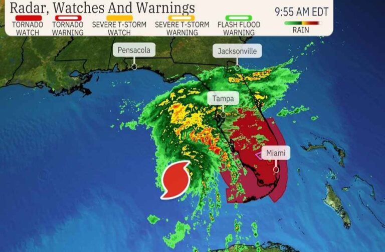
Hurricane Milton, a powerful Category 4 storm with sustained winds of 155 mph, is moving across the Gulf of Mexico and is expected to make landfall on Florida’s central west coast early Thursday morning, according to the National Hurricane Center (NHC). The storm is just 1 mph short of a Category 5 hurricane, making it a highly dangerous and potentially catastrophic event for the state.
Landfall and Timing
Milton is forecast to make landfall near Sarasota, Florida, around 2 a.m. Eastern Time on Thursday. At that point, forecasters expect it to be a low-end Category 4 hurricane, with wind speeds ranging from 130-156 mph. The National Weather Service in Tampa Bay has called Milton a “historic storm,” potentially the worst to hit the area in over 100 years. Earlier projections had suggested Tampa Bay as a possible landfall site, raising concerns for a region that hasn’t faced a direct hit from a major hurricane in a century. However, the NHC has advised not to focus too closely on the exact landfall point, as forecast errors can be up to 40 miles over a 24-hour period.
Destructive Impacts
Milton is expected to bring life-threatening storm surges, with significant rises in water levels along Florida’s Gulf Coast from Flamingo to Yankeetown, including Tampa Bay and Charlotte Harbour. The Atlantic coast from Sebastian Inlet, Florida, to Altamaha Sound, Georgia, is also under a storm surge warning, meaning dangerous water rises could occur from Wednesday evening into Thursday, threatening coastal communities.
In addition to the storm surge, devastating winds are expected along the coast and further inland across central Florida. Tropical storm-force winds are already extending up to 125 miles from Milton’s centre, with the storm’s size expected to grow as it approaches land. These winds could cause widespread structural damage and power outages.
Flash Flooding and Tornado Threat
Milton is forecast to produce catastrophic rainfall, resulting in life-threatening flash flooding across central and southern Florida. Several inches of rain are expected in a short period, exacerbating flood risks in vulnerable areas. There is also the threat of tornadoes across the Florida Peninsula, with a tornado watch in place for southern Florida, including Miami, Tampa Bay, and Fort Myers, until 9 p.m. Eastern Time on Wednesday.
Preparation and Evacuations
The National Weather Service has issued urgent warnings, advising residents to complete all storm preparations and evacuations immediately. As of Wednesday morning, Milton was located 250 miles southwest of Tampa and moving northeast at 16 mph. Rainfall from the hurricane is already affecting parts of Florida, well ahead of the storm’s landfall.
Hurricane warnings have been issued for much of central Florida, from the Gulf coast to the Atlantic, including areas such as Tampa Bay, Fort Myers, Orlando, Cape Canaveral, and Daytona Beach. Tropical storm watches and warnings are also in effect for other parts of Florida, southeast Georgia, southeast South Carolina, and southern North Carolina.
Post-Landfall and Path
After landfall, Milton is expected to weaken quickly as it loses access to the warm waters of the Gulf. However, it will still retain hurricane strength as it crosses Florida, before transitioning into a tropical storm as it moves into the Atlantic by Thursday afternoon.
Key Warnings and Alerts:
- Storm Surge Warning: Florida’s Gulf Coast from Flamingo to Yankeetown, including Tampa Bay and Charlotte Harbour, as well as the Atlantic coast from Sebastian Inlet, Florida, to Altamaha Sound, Georgia.
- Hurricane Warnings: Central Florida, including Tampa Bay, Fort Myers, Orlando, Cape Canaveral, and Daytona Beach.
- Tornado Watch: Southern Florida Peninsula, including Miami, Tampa Bay, and Fort Myers, until 9 p.m. Eastern Time Wednesday.
Residents in the path of Hurricane Milton are strongly urged to heed all warnings and follow evacuation orders.
RELATED | Hurricane Milton: President Biden urges for urgent evacuation


