


Darwin, Australia: Severe Tropical Cyclone Fina has strengthened into a category-three system as it moves towards Darwin, becoming the first November cyclone of this intensity in Australian waters in 20 years.
The city was expected to experience the cyclone’s most severe conditions on November 22, as Fina travelled through the Van Diemen Gulf, drawing closest to Darwin at about 9 pm. Darwin Airport suspended operations from 9 am, and Qantas proactively cancelled several flights for safety.
The airline said that the passengers were being moved to other services, with additional flights planned for Sunday once the weather stabilises. Travellers were urged to check directly with their airline for delays or cancellations.
Severe Tropical Cyclone Fina will pass just north of Darwin this evening as a Category 3 system. A rapid increase in winds later this afternoon and evening is forecast in Darwin.
Current: 12:41 pm CST Saturday 22 November 2025
Latest track map: https://t.co/tEt0sJOHXK pic.twitter.com/j217fVQROA
— Bureau of Meteorology, Australia (@BOM_au) November 22, 2025
The Australian Defence Force was prepared to support the Northern Territory government if necessary, according to MP Luke Gosling, Special Envoy for Defence, Veterans’ Affairs and Northern Australia. Prime Minister Anthony Albanese, speaking while in South Africa, urged those in Fina’s path to prioritise their safety and acknowledged the efforts of emergency responders working during the extreme conditions.
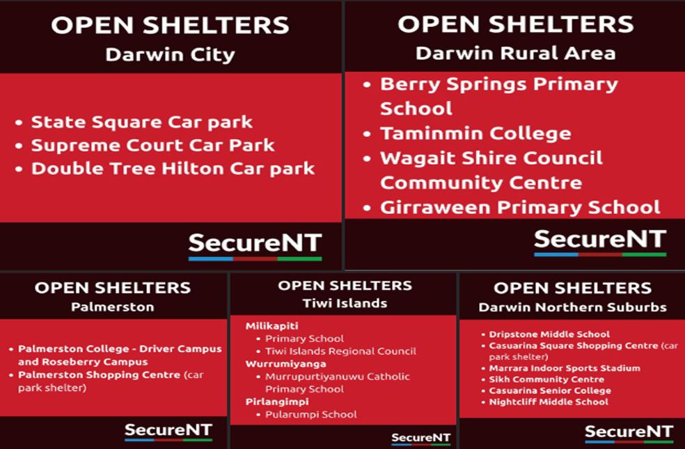
The Northern Territory Emergency Service issued a ‘take shelter now’ emergency warning covering Darwin to Cape Hotham, including Wurrumiyanga on the Tiwi Islands. A watch-and-act alert was in place for Pirlangimpi, Milikapiti, Daly River Mouth to Cape Don, and inland to Batchelor.
As Darwin braced for the cyclone, residents rushed to stock up on essential supplies, with bottled water selling out in some supermarkets by November 19. Authorities confirmed that major supermarkets would close on Saturday, public buses would not operate, and Coles also announced a full-day closure ahead of landfall.
Royal Darwin Hospital activated a code brown, an emergency response protocol to streamline coordination. NT Health noted that emergency plans were active across all regions to ensure continuity of essential services and safety of healthcare staff. Hospitals and clinics across the Top End remained open, with patients advised to attend scheduled appointments unless directly contacted by their healthcare providers.
By November 23, Fina was located about 85km northeast of Darwin, tracking southwest at roughly 9km/h. Senior meteorologist Dean Narramore from the Bureau of Meteorology warned of destructive winds, torrential rain, dangerous flooding, storm surge, and possible outages affecting electricity, water, and gas. Winds near the cyclone’s core reached 185km/h, with the latest track map showing sustained winds of 130km/h and gusts up to 185km/h.
McCluer Island recorded winds of 104km/h overnight, while Point Stuart measured 115.6mm of rain since midnight. Some island areas saw up to 200mm of rainfall in the previous 24 hours. Although Darwin had recorded 20–30mm by early November 22, far heavier rain was expected throughout the day and night.
High tide at around 8 pm was expected to coincide with the cyclone’s peak intensity, increasing risks for coastal areas between 5 pm and 10 pm. Fina is forecast to maintain category-three strength through Sunday and Monday as it heads towards the northern Kimberley coast.
Weatherzone noted that the last cyclone to reach category three in November was Bertie-Alvin in 2005. Fina also ties the record for the earliest tropical cyclone to make landfall after briefly crossing the Cobourg Peninsula before returning over water.
ALSO READ | Stranger Things Ends: Duffers promise bigger, deeper finale